ODK Collect betas are an opportunity to get community feedback on upcoming releases. If you have an ongoing data collection campaign, we recommend quickly verifying your form on a test device. The release will be delayed until all reported issues are fixed.
Joining the beta program
To join the beta program, find ODK Collect in the Play Store and scroll all the way down. Please don't join the beta with a device or account actively used for data collection! In particular, note that joining the beta is account-based. If you use the same Google account across multiple devices, do not join the beta with that account.
Leaving the beta program
You can leave the beta program from the bottom of the Play Store at any time. Once you leave, you will get the next production update when it is released. If you need to go back to the previous production release, uninstall and reinstall the app. Your settings will be reset but your forms will remain (though backups are always recommended).
What to check in this release
This release continues ongoing work to improve the geo widgets in Collect. If you use any of the geo widgets, we recommend you try this release and offer your feedback on the changes. The important changes to try are:
Hello
Great work.
Manually entering points on a background map works in both geotrace and geoshape. Thank you very much that this feature has found input in ODK. However, you will always be forced back to the current GPS position. Is it possible to decouple the manual positioning from the current GPS position and thus navigate freely in the background map? If you turn off gps on the device, then it works. However, my forms always contain the types geopoint and geotrace (manual entry of the lines). Turning GPS off and on again is therefore not very comfortable.
Regards
Dominik
@Dominik, thanks for the feedback! I also see that the map "bounces" back to the GPS location every time a new GPS reading is made even when in manual entry mode. I agree that should not be the case. @zestyping, @yanokwa, what do you think?
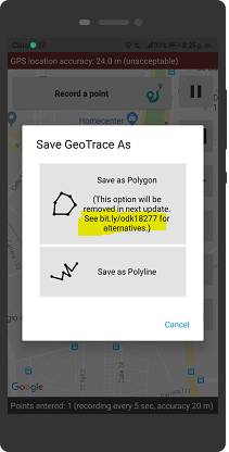
Why not include the direct message "If you use GeoTrace to collect polygons, please update your form to use GeoShape instead"? Because link text is not hyperlink, you have to write it manually to see it.
It's the split between GeoTrace and GeoShape that is being changed. That is, in prior releases of Collect, there was:
GeoTrace to collect either a line or a polygon by getting points at a set regular interval or by the user dropping pins at his/her location
GeoShape to collect a polygon formed by the user manually setting points.
In v1.21 there is:
GeoTrace to collect either a line or a polygon by getting points at a set regular interval or by the user dropping points at his/her location or by the user manually setting points
GeoShape to collect a polygon formed by the user manually setting points or by getting points at a set regular interval or by the user dropping points at his/her location
In future versions there will be:
GeoTrace to collect a line by getting points at a set regular interval or by the user dropping points at his/her location or by the user manually setting points
GeoShape to collect a polygon by getting points at a set regular interval or by the user dropping points at his/her location or by the user manually setting points
In other words, this release makes sure geotrace and geoshape questions can collect points in the three possible ways. The next release will make sure geotrace always collects a trace and geoshape always collects a shape.
The features are great and are being used by the Forestry Department in Kenya to digitally build a Forestry database. Was scared they are going away.....
Hi
Thanks for the new update.
manual positioning of a line over the type geotrace works.
But in the vicinity of my own GPS position can unfortunately set no point
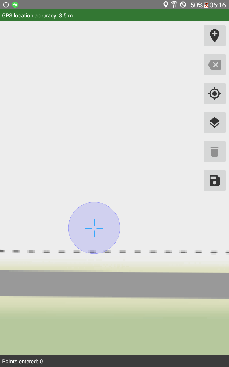
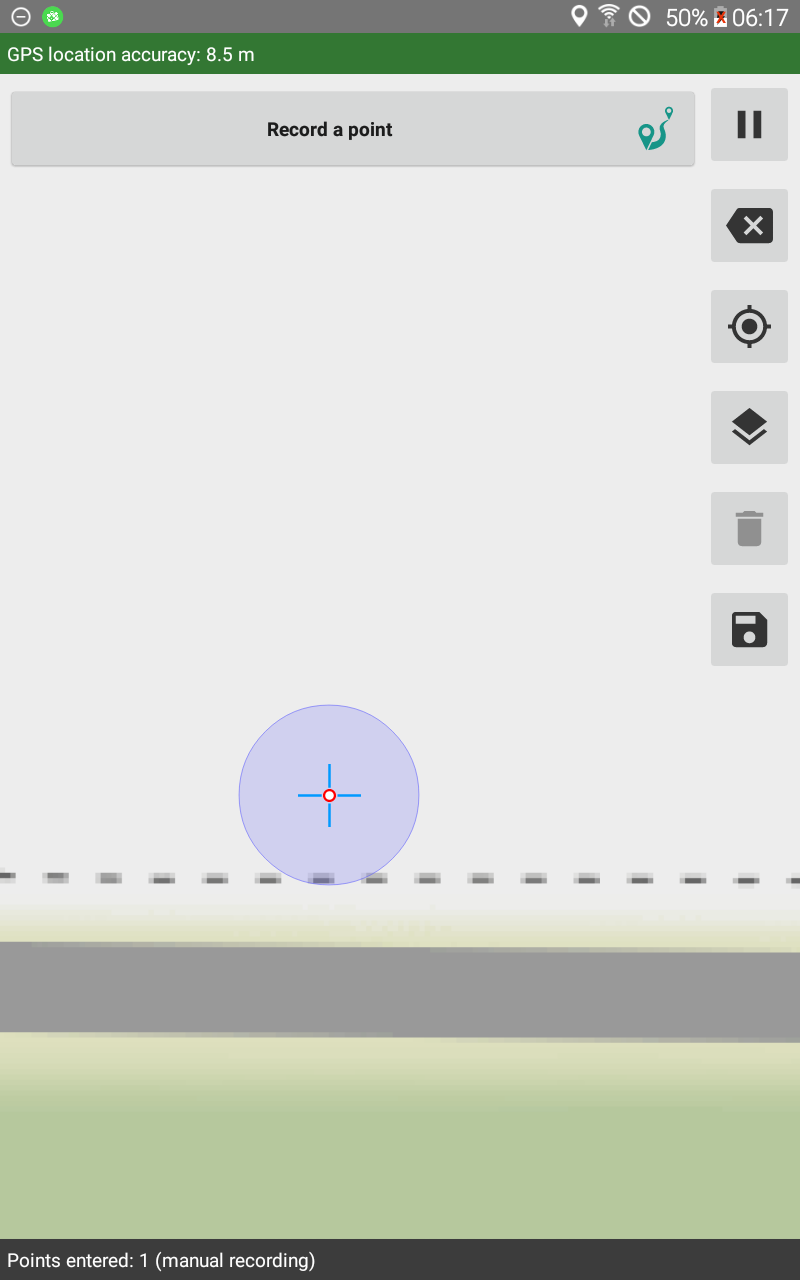
My guess is that the new look of a set point doesn't look like a set point to you, is that possible? I've just verified that I can see my position on a map and drop a point there:
Notice that on the right, there is a red circle that indicates a set point just like when points are set by tapping. Set points used to be indicated by large markers but those made it hard to see the precise location of the point.
If that doesn't explain the problem you're facing, please provide more details.
Video to my problem
On my device (Huawei mate 10 pro with Android 9) the problem is there. How you can see on the video.
Could it be a prob with android version or/and my model?
Thank you so much for that video, @Dominik! You have indeed identified a bug. When using Google Maps, tapping in the accuracy circle recenters the map on your current location instead of placing a point. I've filed an issue at https://github.com/opendatakit/collect/issues/2991 which should be fixed shortly. In the mean time, you can long press to enter points within the accuracy circle.
Hi
I have tested the manual creation of one polyline. It works. However, the point I manually set close to my own GPS position seems to be caught by the gps position marker. But that is not bad in my opinion.