‘One Health Rabies Project’ under the supervision of Dr. Abi Vanak at ATREE aims to understand the spread and prevalence of rabies in free ranging canids in both the urban and the wild landscape. As a part of this project, various aspects of the canid ecosystem including parasitology, immunology, population dynamics, etc. will be studied in depth. The research is taking place in 2 primary regions; the savannah grasslands of Maharastra (Baramati) which will be our analog to rural and wild landscapes and Bangalore which will be our analog site for Urban landscapes.
Need for a unified data collection method:
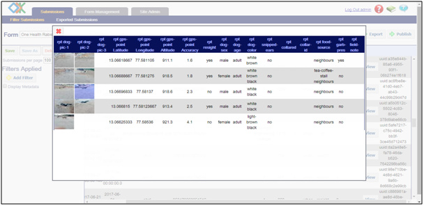
Dog Population Enumeration is a part of the project that requires data to be collected on free ranging dogs from various sites. As the number of sites are geographically distant and also due to the high number of sample sites, we are using a big volunteer network. This creates a need for an unified data collection platform which allows multiple users to pool their observations in order to create a huge database. The ‘Open Data Kit’ has provided an excellent way to achieve these results.
We have been using the traditional ‘Mark and Resight’ method to estimate dog populations in 60 1 sqKm grids around bangalore, where the ‘Open Data Kit’ was first deployed. We collect data on individual dogs like; colour, sex, age, etc. along with several pictures, 4 times over 2 days. The data of each dog is then compared to check for any resights and total god populations are estimated. The platform offers versatile options for collecting data in the form of GPS coordinates, Pictures, and many more, while offering complete customizability and ease of use.
Scope for Further Development:
The fact that the platform can be deployed using any smart device is in fact a great advancement, keeping up with evolving technology. However, during usage, we have noticed certain discrepancies in the derivative android apps from ODK. Loss of data mid survey or during uploads to the ODK server seems to be a tiny but problematic issue. Improvement to the stability of the android app and addition of a few more features such as Asynchronous GPS tracking, in the original app, alleviating the need to the looks for 3rd party apps will reinforce the ‘Open Data Kit’ as the future platform for data collection.
And as you said that during usages your data has been loose you can save there are options in ODK to save data while doing interviews.
You can track GPS activity once you collected data on the server or as soon you saw data you can import data into google earth and then you can track GPS.
Thanks for posting this really interesting project, @shiv_sms! Rabies in free ranging animals is a big problem in many locales and I hope you will share some of your findings as the project advances.
@Stalker I did not know about GPS boosting apps, that's very interesting.
The next release of Collect will update the underlying GPS libraries which should increase accuracy and reduce battery usage.
@shiv_sms Can you please say more about what you mean by asynchronous GPS tracking? Do you mean the ability to collect location in a form without a data collector having to perform an explicit action? Or maybe being able to collect a geotrace while the phone screen is off? Something else...? This might be a good topic for the Features category.
It would also be useful to know more about the data loss issues you are experiencing. The more detail you can provide, the more likely it can be fixed. This would be a great post for Support.
what i mean by "asynchronous GPS tracking" is that although there is geopoint and geotrace as data types within the form, but even before you start filling the form, if there could be a geotrace that could start the moment you open the ODK collect app, it will signify the start of the survey itself as a survey route.
if you can install a ODK derivative app called "Geo Data Collect" you will know what i am talking about.
This feature is part of Geo Odk Collect.
The importance of this feature is that, when surveys are conducted by multiple teams a asynchronous geotrace can be used to track all the routes of each team giving the data managers and analysers the ability understand the pattern of data and the extent of coverage of transects.